
141 mega projects
57 mega projects
81 mega projects
56 mega projects
23 mega projects
96 mega projects
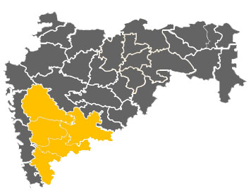
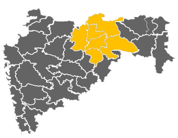
Pune district is head quarter of Pune Region. It is located between 17 degrees 54' and 10 degrees 24' North latitude and 73 degrees19' and 75 degrees 10' East longitude. The district has geographical area of 15.642sq.km. Pune district is bound by Ahmednagar district on north-east,Solapur district on the south-east, Satara district on south, Raigad district on the west and Thane district on the north-west.
It is the second largest district in the state and covers 5.10% of the total geographical area of the state. The landscape of Pune district is distributed triangularly in western Maharashtra at the foothills of the Sahyadri Mountains.
| Pune - Industrial Infrastructure | |
| Area | 57268 sq. km |
| Districts | 5 — Pune, Satara, Kolhapur, Sangli, Solapur |
| Road | NH-4, NH-9, NH-13 and NH-204, Mumbai-Pune Express Highway |
| Power | 1 Thermal Power Station |
| Connectivity with Mumbai | Pune - 154 km Satara - 250 km Kolhapur - 375 km Sangli - 396 km Solapur - 450 km |
| Leading Sectors | Auto Manufacturing, Bio Technology, IT/ITES, Textiles, Sugar, Wine, Food Processing, Foundry |
| Taluka Classification | Pune - A,B,C,D,D+, Solapur – D,D+, Satara - D,D+, Sangli – D,D+, Kolhapur – D,D+ |
| Mega Projects Description | |
| Total Mega Projects | 117 |
| Total Investment (₹) | 77,754.86 |
| Employment Generated | 187,377 |
| Taluka Classification | Pune - A,B,C,D,D+, Solapur – D,D+, Satara - D,D+, Sangli – D,D+, Kolhapur – D,D+ |
| Industrial Infrastructure | |
| Number of Industrial Units | 9,273 |
| Number of plots developed | 17,476 |
| MIDC IT Parks | 37 |
| Other Parks | 7 |
| SEZs | 20 |
| MSME | 68,080 |
| Large Enterprises | 1490 |
| Mega Projects | MSMEs (2006-07 to 2014-15) | ||||
| No. of Mega Projects | Investment (₹. In Crores) | Employment (In Numbers) | No. of MSMEs | Investment (₹. In Lakhs) | Employment (In Numbers) |
| 141 | 89301.35 | 202027 | 85253 | 1419873 | 962638 |
| IT Parks | BT Parks | SEZ | ||
| No. of IT Parks | No. of BT Parks | No. of BT SEZ | Notified | Approved |
| 171 | 4 | 3 | 21 | 14 |
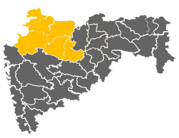
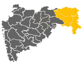
Nashik District is a headquarter of Nashik Region and also the third most industrialized city in Maharashtra, and one of the fastest growing cities of India; is also referred to as the "Wine Capital of India", and India’s Napa Valley. It is located in the Western Ghats, northwest of Maharashtra; 180 km from Mumbai and 202 km from Pune.The city is the administrative headquarters of Nashik district and Nashik Division.
The picturesque city located on the banks of the Godavari, is known for its pleasant climate. The river flows out from Trimbakeshwar that lies southwest of the city. The famed Nassak Diamond borrows its name from this city only.
| Nashik - Industrial Infrastructure | |
| Area | 57426 sq. km |
| Districts | 5 — Nashik, Ahmednagar, Jalgaon, Dhule, Nandurbar |
| Road | NH-50, NH-3 and NH-6 |
| Power | Thermal Power Plant in Eklahare Thermal Power Station Coal/Gas based in Bhusawal |
| Connectivity with Mumbai | Nashik - 185 km Ahmednagar - 285 km Jalgaon - 420 km Dhule - 360 km Nandurbar - 380 km |
| Leading Sectors | Engineering, Manufacturing, Plastic Pipe, Food Processing, Aircraft Manufacture and Alternative Energy |
| Taluka Classification | Nashik-B,C,D,D+, Ahmednagar-D,D+, Dhule- D,D+, Nandurbar-D+, Jalgaon-D,D+ |
| Mega Projects Description | |
| Total Mega Projects | 52 |
| Total Investment (₹) | 14,612.38 |
| Employment Generated | 24,612 |
| Taluka Classification | Nashik-B,C,D,D+, Ahmednagar-D,D+, Dhule- D,D+, Nandurbar-D+, Jalgaon-D,D+ |
| Industrial Infrastructure | |
| Number of Industrial Units | 6,747 |
| Number of plots developed | 10,546 |
| MIDC IT Parks | 3 |
| Other Parks | 6 |
| SEZs | 6 |
| MSME | 19,911 |
| Large Enterprises | 665 |
| Mega Projects | MSMEs (2006-07 to 2014-15) | ||||
| No. of Mega Projects | Investment (₹. In Crores) | Employment (In Numbers) | No. of MSMEs | Investment (₹. In Lakhs) | Employment (In Numbers) |
| 57 | 18000.28 | 26528 | 25581 | 591734 | 301005 |
| IT Parks | BT Parks | SEZ | ||
| No. of IT Parks | No. of BT Parks | No. of BT SEZ | Notified | Approved |
| 4 | - | - | 1 | - |
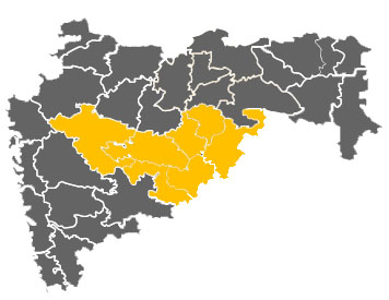
Marathwada identifies one of the six regions in Maharashtra state of India. It is made up of Aurangabad and Nanded sub division. Aurangabad District is a head quarter of Aurangabad Division and Nanded District is a head quarter of Nanded Division. The world heritage sites of Ajanta and Ellora caves are located near Aurangabad. Marathwada is referred to as the land of Saints.
There has been accelerated industrial growth in Marathwada in the past few years and many key players have started major projects in this region.
| Aurangabad - Industrial Infrastructure | |
| Area | 64811 sq. km |
| Districts | Aurangabad Divisions (4 Districts) — Aurangabad, Jalna, Beed, Osmanabad Nanded Sub Division (4 Districts) - Latur, Nanded, Parbhani, Hingoli |
| Road | NH-211, Nagpur-Aurangabad-Mumbai Express Highway |
| Power | Thermal Power Station Coal/Gas based in Parli |
| Connectivity with Mumbai | Aurangabad - 375 km Jalna - 450 km Beed - 450 km Osmanabad - 438 km Hingoli - 676 km Latur - 487 km Nanded - 617 km Parbhani - 560 km |
| Leading Sectors | Automotive, Pharmaceuticals, Aluminium, Bio Technology |
| Taluka Classification | Aurangabad – D,D+, Jalna, Beed, Osmanabad, Parbhani – D+, Hingoli – No Industry District |
| Mega Projects Description | |
| Total Mega Projects | 72 |
| Total Investment (₹) | 16,812.32 |
| Employment Generated | 33,738 |
| Taluka Classification | Aurangabad – D,D+, Jalna, Beed, Osmanabad, Parbhani – D+, Hingoli – No Industry District |
| Industrial Infrastructure | |
| Number of Industrial Units | 4,577 |
| Number of plots developed | 11,068 |
| MIDC IT Parks | 3 |
| Other Parks | 8 |
| SEZs | 11 |
| MSME | 11,174 |
| Large Enterprises | 538 |
| Mega Projects | MSMEs (2006-07 to 2014-15) | ||||
| No. of Mega Projects | Investment (₹. In Crores) | Employment (In Numbers) | No. of MSMEs | Investment (₹. In Lakhs) | Employment (In Numbers) |
| 81 | 20735.99 | 39874 | 16149 | 439283 | 175990 |
| IT Parks | BT Parks | SEZ | ||
| No. of IT Parks | No. of BT Parks | No. of BT SEZ | Notified | Approved |
| 3 | - | 1 | 7 | 3 |
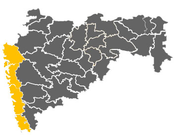
The Konkan, also called the Konkan Coast or Karavali is the name given to a stretch of rugged western coastline of India from Raigad to Mangalore. Greater Bombay consists of the City of Bombay and the Bombay Suburban District.The City of Bombay was a separate unit, and was not included in a division and was included in the Konkan Division. A division has a Divisional Commissioner in charge. Thane District is a head quarter of the Thane Region.
District Collector is in charge of District, and taluka is placed under Tehsildar. For each village or a group of villages a Talathi is appointed for revenue administration.
| Konkan - Industrial Infrastructure | |
| Area | 30746 sq. km |
| Districts | 6 — Mumbai City and Mumbai Suburban, Thane, Raigad, Ratnagiri, Sindhudurg |
| Road | NH-17,NH-4 and NH-8, Mumbai Pune Express Highway, Extension of Expressways Vadodara-Mumbai |
| Power | Tarapur Atomic Power Station Uran Gas Turbine Power Plant |
| Connectivity with Mumbai | Thane - 40 km Raigad - 120 km Ratnagiri - 330 km Sindhudurg - 481 km |
| Leading Sectors | Banking, IT, Plastics, Rubber, Steel, Pharmaceuticals, Engineering, Fertilizer |
| Taluka Classification | Greater Mumbai - A, Thane, - A, B,C,D+, Raigad – A to D+, Ratnagiri – C, D,D+, Sindhudurg – D, D+ |
| Mega Projects Description | |
| Total Mega Projects | 49 |
| Total Investment (₹) | 13,9578.66 |
| Employment Generated | 49,956 |
| Taluka Classification | Greater Mumbai - A, Thane, - A, B,C,D+, Raigad – A to D+, Ratnagiri – C, D,D+, Sindhudurg – D, D+ |
| Industrial Infrastructure | |
| Number of Industrial Units | 11,125 |
| Number of plots developed | 19,334 |
| MIDC IT Parks | 10 |
| Other Parks | 6 |
| SEZs | 60 |
| MSME | 25,625 |
| Large Enterprises | 1222 |
| Mega Projects | MSMEs (2006-07 to 2014-15) | ||||
| No. of Mega Projects | Investment (₹. In Crores) | Employment (In Numbers) | No. of MSMEs | Investment (₹. In Lakhs) | Employment (In Numbers) |
| 56 | 147333.27 | 54039 | 59095 | 2299086 | 960278 |
| IT Parks | BT Parks | SEZ | ||
| No. of IT Parks | No. of BT Parks | No. of BT SEZ | Notified | Approved |
| 287 | 2 | 4 | 29 | 5 |
Amravati is in the eastern region of Maharashtra state. It is also headquarter of Amaravati region. It borders the state of Madhya Pradesh to the north, Andhra Pradesh to the south and Marathwada and Khandesh regions of Maharashtra to the west.
Situated in central India, it is a part of Vidarbha which has its own rich cultural and historical background distinct from rest of Maharashtra.
| Amravati - Industrial Infrastructure | |
| Area | 46090 sq. km |
| Districts | 5 — Akola, Amravati, Buldhana, Washim, Yavatmal |
| Road | NH-6 and NH-7, Amravati-Morshi State Highway |
| Power | 1 Thermal Power Station |
| Connectivity with Mumbai | Amravati - 673 km Akola - 585 km Buldhana - 500 km Yavatmal - 780 km Washim - 664 km |
| Leading Sectors | Minerals, Forest, Food, Agriculture |
| Taluka Classification | All Talukas of Amravati, Akola, Buldhana, Washim, Yavatmal - D+ |
| Mega Projects Description | |
| Total Mega Projects | 21 |
| Total Investment (₹) | 12,825.86 |
| Employment Generated | 12,843 |
| Taluka Classification | All Talukas of Amravati, Akola, Buldhana, Washim, Yavatmal - D+ |
| Industrial Infrastructure | |
| Number of Industrial Units | 1,589 |
| Number of plots developed | 4,697 |
| MIDC IT Parks | 1 |
| Other Parks | 0 |
| SEZs | 2 Approved 2 Notified |
| MSME | 4,689 |
| Large Enterprises | 148 |
| Mega Projects | MSMEs (2006-07 to 2014-15) | ||||
| No. of Mega Projects | Investment (₹. In Crores) | Employment (In Numbers) | No. of MSMEs | Investment (₹. In Lakhs) | Employment (In Numbers) |
| 23 | 13176.36 | 14058 | 12451 | 135005 | 106858 |
| IT Parks | BT Parks | SEZ | ||
| No. of IT Parks | No. of BT Parks | No. of BT SEZ | Notified | Approved |
| - | - | - | 3 | - |
Vidarbha is the eastern region of Maharashtra state made up of Nagpur and Amravati Division. Nagpur District is the headquarter of Nagpur Region. It borders the state of Madhya Pradesh to the north, Chhattisgarh to the east, Andhra Pradesh to the south and Marathwada and Khandesh regions of Maharashtra to the west.
Situated in central India, it is a part of Vidarbha which has its own rich cultural and historical background distinct from rest of Maharashtra.
| Nagpur - Industrial Infrastructure | |
| Area | 51377 sq. km |
| Districts | 6 — Wardha, Nagpur, Chandrapur, Bhandara, Gadchiroli, Gondia |
| Road | NH-6, NH-7 and NH-69 |
| Power | Koradi Thermal Power Station Khaparkheda Thermal Power Station Chandrapur Thermal Power Station |
| Connectivity with Mumbai | Nagpur - 830 km Wardha - 750 km Chandrapur - 877 km Bhandara - 895 km Gadchiroli - 1000 km Gondiya - 991.0 km |
| Leading Sectors | Minerals, Forest, Food, Agriculture |
| Taluka Classification | Nagpur-D,D+, Bhandara, Gondia, Wardha and Chandrapur- D+, Gadchiroli- NID |
| Mega Projects Description | |
| Total Mega Projects | 86 |
| Total Investment (₹) | 57,207.05 |
| Employment Generated | 45,909 |
| Taluka Classification | Nagpur-D,D+, Bhandara, Gondia, Wardha and Chandrapur- D+, Gadchiroli- NID |
| Industrial Infrastructure | |
| Number of Industrial Units | 2,687 |
| Number of plots developed | 5,518 |
| MIDC IT Parks | 6 |
| Other Parks | 1 |
| SEZs | 8 Approved 6 Notified |
| MSME | 15,609 |
| Large Enterprises | 541 |
| Mega Projects | MSMEs (2006-07 to 2014-15) | ||||
| No. of Mega Projects | Investment (₹. In Crores) | Employment (In Numbers) | No. of MSMEs | Investment (₹. In Lakhs) | Employment (In Numbers) |
| 96 | 66139.09 | 51419 | 24972 | 361148 | 246752 |
| IT Parks | BT Parks | SEZ | ||
| No. of IT Parks | No. of BT Parks | No. of BT SEZ | Notified | Approved |
| 6 | - | - | 5 | 2 |